General Assembly
Lawmakers clash after House panel approves updated congressional map

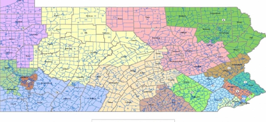
The House of Representatives’ preliminary congressional map The Pennsylvania House Republican Caucus
A GOP-led House panel approved an updated preliminary congressional map that proponents hailed as a “starting point” in the state’s quest to draw new congressional districts, though the process by which the maps were advanced received criticism from Democrats on the committee.
The House State Government Committee voted 14-11 on Wednesday to amend the committee’s preliminary congressional map, which was released by Committee Chair Seth Grove last week. The updated map, which is based on a draft submitted by former Lehigh County Commissioner Amanda Holt, made several key changes from the original version.
Grove, speaking to members of the committee, said the map makes changes to the state’s 3rd Congressional District, increasing the district’s African American voting age population from 49% to 59.49%. He said the updated draft was also altered to move Willistown, in Chester County, from the state’s 5th Congressional District to the 6th Congressional District.
RELATED ARTICLES
The new map also makes Lebanon County whole by putting it into one congressional district, and splits Dauphin County into three congressional districts. Divisions splitting Blair County were also redrawn, putting the county into the 13th Congressional District.
Grove said the changes were based on public comment and a desire to make districts more compact. He said a large majority of the state's population remained in districts in Holt’s original map.
“We looked at compactness, and we looked at public comments to do the adjustments in the updated map. That updated map ended up being 95% the same map on population and land use,” he said. He also praised the process by which the House has fielded public input from citizens, which he said “has never been done by this chamber.”
Democrats, however, took issue with both the new map and the process by which it was advanced.
State Rep. Scott Conklin, the committee’s minority chair, said that by making changes to the “citizens” map – i.e., the map drawn by Holt – it no longer should be considered a “citizens” map.
“Today, what we're about to do, is we're going to throw the citizens map out, and we're going to amend it again,” Conklin said. “It's no longer the citizens map. Please – no one call it the citizens map. Once you buy a car from somebody, it's no longer their car. You own it. You bought it. You modified it. You're responsible for it.”
Democrats, including Conklin, also said they were largely left out of the process of developing the committee’s preliminary maps.
“I hear the word transparent over and over and over again, at this meeting and the meetings previously, but you know what the word I don't hear is? I don't hear the word bipartisan,” said state Rep. Maureen Madden, who voted against the map.
The map also got one Republican “no” vote from state Rep. Ryan Mackenzie, who said he would like to see more time for lawmakers to factor in public comments.
Grove stressed that the public will have more time to comment on the draft map. Ultimately, a congressional map will have to be approved by both chambers of the General Assembly and signed by the governor. He added that partisan considerations were not taken into consideration when drafting the updated map and stressed that they should not influence congressional or legislative maps. “We will get a map for the people done that removes the politics out of this,” he said.
